Dengue Mapping with Google Street View
Each year, 100 - 400 million people globally suffer from Dengue Fever, with around half of the world’s population being at risk. The rate of infection has grown significantly in recent decades, and Severe Dengue is the leading cause of serious illness and death in some Asian and Latin American countries. The level of infection, combined with the lack of an available vaccine, makes Dengue one of the world’s most significant Public Health concerns.
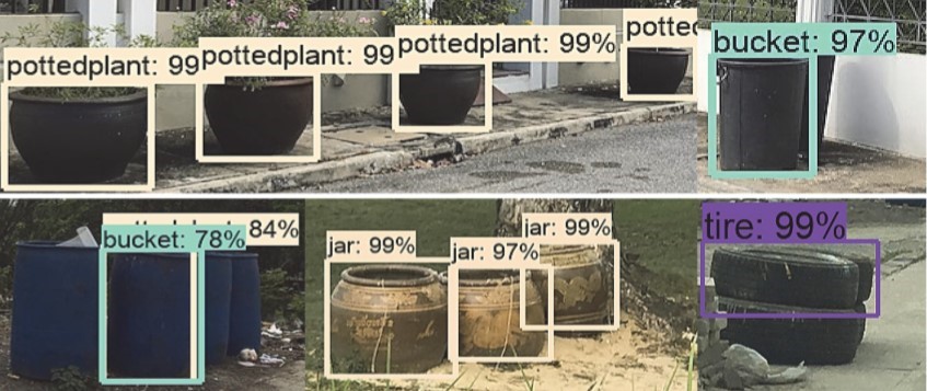
Prof. Dr. Peter Haddawy, Dr. Myat Su Yin, and Asst. Prof. Dr. Anuwat Wiratsudakul, of the Mahidol-Bremen Medical Informatics Research Unit, located in the Faculty of Information and Communication Technology (ICT), Mahidol University, have been taking a new approach to the issue of Dengue. Dengue is spread by specific types of mosquitos, in particular A. aegypti, which breed in small containers which hold stagnant water. The Faculty of ICT have developed a new way to identify high risk areas for Dengue Fever, by mapping the density of containers where the mosquitos can breed.
Although this type of mapping has been in existence for many years, when performed manually it is incredibly time consuming. Teams of trained people would visit an area, such as a suburban district, and walk around noting where they see different types of small containers, ranging from trash cans, to flower pots, to discarded car tires that contain mosquito larvae. As it takes so much time for a team to cover even a small area in this manner, it is not fit for practical implementation. The researchers at the Faculty of ICT have automated this process with the help of images available on the Google Maps Street View tool.
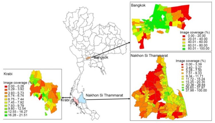
So far, the research has covered 3 provinces around Thailand: Bangkok, Nakhon Si Thammarat, and Krabi. The software harvests images from Street View, with around 1 million images for each province. It then uses convolutional neural network transfer learning to identify 8 common types of containers which may be breeding sites for Dengue mosquitos. Combining this with the geotagged data from the images, it is possible to create large-scale detailed mapping of Dengue vector breeding sites.
At present, the software has been tested in a variety of ways. The object recognition algorithm has an accuracy of 0.91 in terms of F-score, a measure of accuracy that considers both precision and recall Container counts from the Street View images has also been compared with existing manually-collected data, showing that the number of containers which the program finds is accurate. The densities of the 8 types of container which the system identifies have also been found to be a good predictor of the presence of Dengue mosquito larvae during the rainy season.
In practice, this new tool, in combination with other datasets such as rainfall patterns, can help to identify places with a high risk of Dengue infections. This can help governments in Thailand and around the world to target interventions with awareness, prevention, and treatment. Work is now ongoing to use the generated data to build models to predict risk of infection.